
This scenic drive is a curvey, wandering, figure-8 through a beautiful section of Sauk County and the Driftless region of Wisconsin. What’s more, we’ve mapped it out to take you to 7 Wisconsin State Natural Areas and 1 Wisconsin State Park, so our 2-hour drive and can easily turn into an all-day exploration! Along the way, you’ll see amazing rural landscapes, wide vistas, deep forests, and even get your car dusty on one of Wisconsin’s (gravel) Rustic Roads.
Please be sure to download a Google Map for this section (For offline viewing) or print a map out because cell service will drop out regularly on this tour.
Section 1: Baraboo to Natural Bridge State Park
We start this drive at the intersection of Hwy 136 and South Boulevard just east of Highway 12. This is a great place to start since you can fill your tank at the Kwik Trip and visit Wildside Action Sports as well. :) From here you’ll simply head west on South BLVD, through the 2 round-a-bouts under Highway 12 and continue west on County Road W. It won’t be long before you’ll drive past New Life Lavender farm… Or that could be your first stop!
Continuing on, the first Wisconsin State Natural Area you’ll come to is Pewit’s Nest SNA. There is a small parking lot here. If you want to stop, you’ll want to be here early in the morning or during the week to get parking. The hike takes less than an hour.
One mile west of Pewit’s Nest SNA we’re going to get off the main road and jump onto Hoot Owl Valley Road. This is a weird little intersection, watch that you stay on Hoot Owl Valley going west. In 1/2 mile, there will be a right-hand turn on Fairview Road. Take it IF you want to visit the small McGilvra Woods State Natural Area (known for its spring woodland flowers) or continue straight.

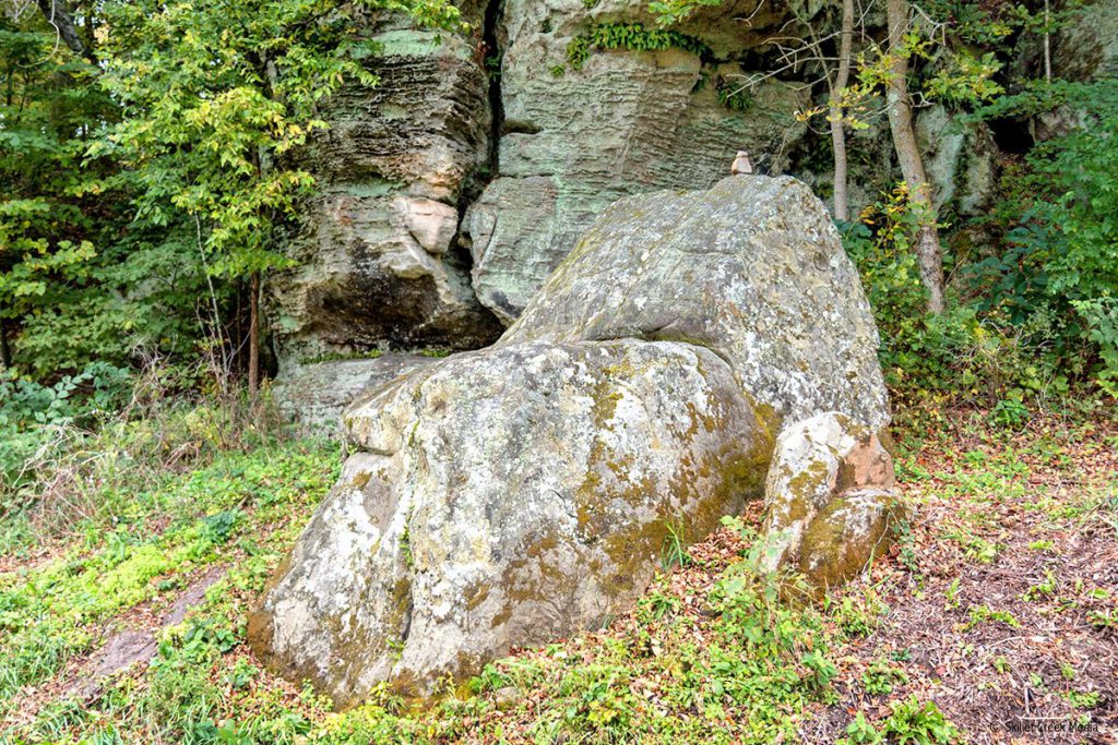
Just another half mile ahead and the road will take a sharp right turn and at the same time shrink to a tight single lane. (In the UK they’d call this a “B” Road.) Take it slow. The road will drop down into a little valley (Hoot Owl Valley) with an awesome rock formation on your right. Then you’ll drive back up the tight road out of the valley and continue west. You’ll come to a “T” on Klingenmeyer road. Turn right. (South)
Soon we’ll at another intersection and we’ll take county road W west gain. Past the winding, rolling farm fields you’ll soon get some amazing views and the road drops down a long hill and stops at another “T”. Turning left here you could go to the Mid-Continent Railway Museum and North Freedom but we’ll go right and stay on County Road W. About a half-mile from the intersection, watch for the rock formation called “Devil’s Chair” on the right. It’s a fun selfie-spot for kids.
Just a bit past the Devil’s Chair, CTY W turns left, here, we’ll go straight onto County Trunk Highway PF. Watch for the low rock ridge on the right. We’re going to stay on PF for about 7 miles. There will be some great rolling country to see and some awesome vistas as you top hills along the way. (Watch for the place that sells those old kiddie rides that used to be at the front of grocery stores!)

Your next turn will be a right onto a designated Wisconsin Rustic Road called, “Schara Rd.” (We call it Sriracha Road.) Yes, it’s a gravel road but in good condition.

Schara road will offer two opportunities to enter Hemlock Draw State Natural Area. First, you can drive down Buck Feaver Road to a small parking lot, or farther up Schara, there is a new lot on the left-hand side of the road. Otherwise, Continue to a “T” in the road and turn left on Orchard Road.

You’ll see what a perfect fall color drive this area can be! Orchard Road will take you south to County Road C. Along the way you’ll pass parking for Pine Hollow State Natural Area. There is a trail to the forest, but from there you are on your own.
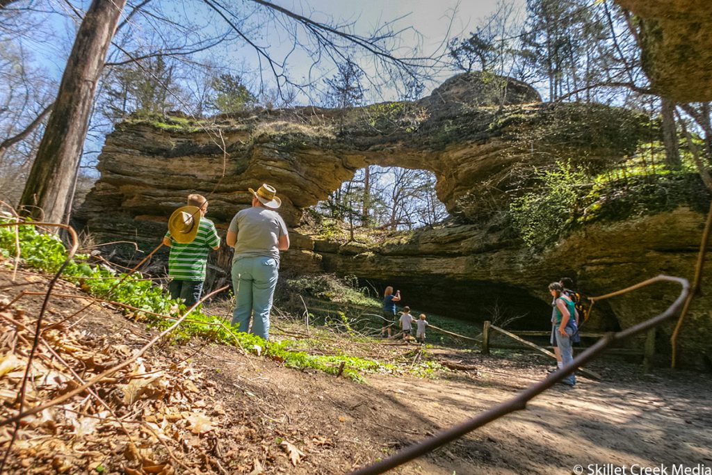
At County Highway C you’ll be at another “T” in the road. Turn left. In less than a mile, Natural Bridge State Park will be on your left. Here there is a fairly short hike to a Sandstone Arch similar to what you would see in Utah… Well, with more trees! This is the end of section 1.
Section 2: Natural Bridge State Park to Denzer Road
This section loops us back around and offers some of the best Driftless scenery you could want on a scenic drive. Pulling out of Natural Bridge State Park, we’re going to turn left on County Trunk C, and drive toward Leland, WI. There is a park with restrooms and a couple of small taverns where I’m told you can get great burgers! After lunch, or if you’re just continuing on, we’ll turn left on Hemlock Road. There are two interesting sandstone formations to see here. One is right along Hemlock and the other will be off to your west in the distance.
About 1 mile north of Leland, Hemlock Road will meet Reich Road. You’ll want to turn right and stay on Hemlock. That said, Reich Rd. leads to another access to Hemlock Draw State Natural Area.
Continuing east on Hemlock Road, were’ going to do a little jog here. When Hemlock meets CTY PF, turn left and then in just a few yards, turn right onto Skyview Road and continue East. If you blink, you’ll fly right past Honey Creek State Natural Area. From when you turned ontly Skyview road, it’s only .3 miles to Alder Drive on your left which will take you up to the unstaffed Cox Nature Center. There is, however, a pit toilet here if you need one. The trailhead into Honey Creek SNA is just about 30 yards east of Alder Rd on the left side of Skyview Road. There is really no good parking. We park further back and walk up the road. This trail goes for a little way before disappearing into the tall grass and brush. Honey Creek is known as a popular birding location with more than 80 species have been recorded. Unusual nesting species include veery, blue-gray gnatcatcher, yellow-throated vireo, and blue-winged warbler. Read More.
From the Honey Creek SNA we’ll just take in the scenery as we drive about 5 miles to join County Highway W. Well turn left on W, heading west.
After 2.25 miles on County W, we’ll continue straight onto County D, at the intersection. County D will weave around a bit and bring us back to County PF. You’ll remember this bit! Turn right. We’re going to backtrack a bit here, but coming from this direction on PF you’ll get a much better view of the landscapes and vistas. After about 4 miles of heading east on PF, we’ll catch a left turn onto Denzer Road. This ends Section 2 of your road trip. Denzer Road is the beginning of the last Section which will bring us back to the start.
Section 3: Dezner Road Back To Baraboo
You’ll drive Denzer road for almost 4 miles weaving through the rolling driftless countryside rising up to 1400ft and dropping over 500 feet before you’ll turn on Hilltop Road. Heading east, you’ll climb right back up the hill again. At the top of this hill, if the corn is cut, you’ll have some great views to your south. Pan Hollow State Natural Area is about 1 mile from Dezner Road. The path in will be on your right. There are no signs, there is no parking provided and no trails. In fact, it’s hard to even see Pine Hollow. Hiking in from here generally leads to wet feet, but there are some interesting farm ruins and rock formations if you are the exploratory type. Otherwise, continue on to the “T” in the road. This is Freedom Road.
You’ll turn right (North) on Freedom Road. (It’s worth mentioning that just left of the intersection on the east side of the road is a place called “Leopold Memorial Woods”. Again, a great place to explore, but it’s not marked and hard to navigate. Just past Leopold Woods is an old log home as well. Great for pictures! That said, the main goal here, is to head north on Freedom Road. ) We’ll climb to nearly 1480 feet, which is as high as we get on this drive. After about 2.5 miles, we’ll turn left onto Happy Hill Road.

Happy Hill is a scenic drive that basically traces the southern foot of a bluff and follows the contours of Pine Creek. At about the 3.3 mile mark you can take a left on Forest Drive to reach the northern border of Baxter’s Hollow State Natural Area. This gravel road leads to a small parking area. There is a trail from there. This is an “out-n-back” hike since the trail just continues on to the southern end. Again, once you’re back out to Happy Hill road, we’re still heading east.
Happy Hill Road will curve north and lead you back to a “T”. (See the photo at the top of the page.) This is County W. Turn right. County W will take us straight Back to Baraboo! If you’re observant, you’ll notice within less than a mile we’re back on familiar ground. We’ll pass Hoot Owl Valley Road again, that Lavendar Farm and soon be right back at Highway 12 and entering Baraboo.
Google Map
Map Link: https://drive.google.com/open?id=1HjxvF0j5r8sTC8Putl_XnywkW2BElVaL&usp=sharing